Import World Creator
Import World Creator makes a new map from a terrain you made in World Creator. The heights come from its heightmap, and the ground textures come from its splat maps. The open map closes.
What the export needs
Put these files in one folder:
| File | What it is |
|---|---|
The .xml file | The export's description. RustEdit reads its Surface: Width is the map size, and Height, MinHeight and MaxHeight set the heights. |
heightmap.raw | The heights. A square RAW file, 16 bit (low byte first) or 8 bit. |
splatmap_00.tga, splatmap_01.tga | The splat maps, 4 layers each. Square, the same size, not compressed, 24 or 32 bit. |
Without the splat maps, RustEdit still makes the map. The ground is then one texture.
Heights
The heights go from Height x MinHeight to Height x MaxHeight meters. RustEdit counts them from the bottom of Rust's terrain, 500 meters under sea level. So 500 meters in World Creator is sea level in Rust.
For example: with Height 1000, the lowest ground is 500 meters under the sea and the highest is 500 meters over it. Keep your land above 500 meters in World Creator, or move it with Height Offset.
Then the options change them:
- Height Scale multiplies every height, counted from sea level. The coast stays where it is: land gets higher and the sea floor deeper. 1 keeps the heights.
- Height Offset adds meters to every height. Use it to lift land out of the sea, or to lower it.
Rust's terrain goes from 500 meters under sea level to 500 meters over it. Ground that ends up lower or higher is cut flat there. The box under Export File warns you when that happens.
Splat layers
The first 8 layers in World Creator become Rust's 8 ground textures, in this order:
| Layer | File and channel | Rust texture |
|---|---|---|
| 1 | splatmap_00.tga red | Dirt |
| 2 | splatmap_00.tga green | Snow |
| 3 | splatmap_00.tga blue | Sand |
| 4 | splatmap_00.tga alpha | Rock |
| 5 | splatmap_01.tga red | Grass |
| 6 | splatmap_01.tga green | Forest |
| 7 | splatmap_01.tga blue | Stones |
| 8 | splatmap_01.tga alpha | Gravel |
How to import a World Creator terrain
- Save the open map if you want to keep it. The import closes it.
- Click . The Import World Creator dialog opens.
- Click Export File and pick the export's
.xmlfile. - Check the box under it. It says what the new map will be, or what is missing.
- Set the World Size, Height Scale and Height Offset if you need to. The box shows the new lowest and highest ground as you change them.
- Pick the Terrain Resolution and Texture Resolution.
- Click Import, then Confirm. RustEdit makes the new map.
- Save the new map.
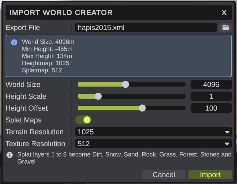
Options
| Option | What it does |
|---|---|
| Export File | The .xml file World Creator exported. The other files must be in the same folder. |
| The box | What the new map will be: World Size, Min Height and Max Height (the lowest and highest ground in Rust's meters, sea level is 0, with the options below), and the size of the Heightmap and the Splatmap. When something is missing, it says what, and Import is grayed out. |
| World Size | The new map's size, from 1000 to 8000 meters. It starts at the export's Width. A different size stretches or shrinks the terrain to fit. |
| Height Scale | Multiplies every height, counted from sea level, from 0.1 to 5. 1 keeps the heights. See Heights. |
| Height Offset | Meters added to every height, from -500 to 500. 0 keeps the heights. |
| Splat Maps | Paints the splat maps onto the ground. Turn it off to import only the heights: the ground is then one texture. Grayed out when the export has no splat maps. |
| Terrain Resolution | The resolution of the new map's heights. It starts at the heightmap's own size when a map can have it. |
| Texture Resolution | The resolution of the new map's ground textures. It starts at the splat maps' own size when a map can have it. |
Above 6000 meters, a warning box shows under Export File. See Maps larger than 6000 m.
A heightmap smaller than the terrain resolution is stretched and smoothed a little, so its pixels do not show as steps. The biome and the topology of the new map are the same everywhere, as on a new empty map.
The import is not an undo step. To go back, open the map you saved before.